WebText- GEOGRAPHY
OF
Chapter 7 –
DRAFT webtext by G.
Atwood, 2012
Use with
professional courtesy and attribution including attribution of original sources
where indicated.
Subtitle:
BIG CONCEPTS: This chapter explores
- Systems have subsystems. The hydrosphere is a subsystem of Earth systems, the subsystem of water… the “water - Earth.”
- Surface water runs downhill. Elevation contours indicate “downhill" as well as elevation.
- Watersheds are areas on Earth’s surface that collect water that flows to a given place. The area, however great or small that “sheds water” toward a specific place is its watershed. Divides separate watersheds. Everything goes somewhere
- Rivers are fed by watersheds. Broad regions based on watersheds are called drainage basins. Utah has two major drainage basins and a small portion of a third.
- Understand the water cycle (a.k.a. hydrologic cycle) and be empowered. The water cycle and Utah geography.
- Out of sight, out of mind. Groundwater hydrology is rarely simple but ever more-important
to human geography
- Information literacy: regional hydrology might be considered Earth sytems 101. County-scale hydrology... that's Earth Systems 301.
- Utah is a water-scarce state with highly uneven distribution of the resource. Of course water is managed intensely.
- Wet water versus paper water… water resources versus water rights. Water rights govern water usage.
- Urban water supplies may come from afar… dams, diversions, politics, and water. First in time, first in right. Case history of water appropriations: sources of UofU drinking
water. A history of
EVIDENCE. Examine these images in the context of water…
Water Resources: IHC-1996-UT-facilities
Regions: RegionsHydroVsGeo
Scenery: BYU-Hamblin-p286-WeberDeltaGSL
Scenery: BYU-Hamblin-p228-TuleValley
Scenery: BYU-Hamblin-p211-NaturalistBasin-HighUintas
Scenery: BYU-Hamblin-p121-Goosenecks
Scenery, resources:
BYU-Hamblin-p166-LakePowell
Resources: Utah Power Board River Flows
GovtInstitutions,
management regions:
Quotation:
Governor Matheson:
during the floods of Spring 1983: “This is one hell-of-a-way to run a desert” – photo permission of Norma Matheson.
LINK to The 15 Themes of Geography of Utah.
CASES:
Wasatch front
hydrology: Arnow
Topics… Questions to Ponder –
Why is Utah's water where it is?
Where does it flow, and why?
Why is the State Engineer, the person who allocates water in Utah, a constitutional position, only able to be replaced every 4 years?
Overarching Goal of the Chapter:
Skepticism… know
that everything you read and hear about water and
MAJOR CONCEPT:
Expansion on the
“major concept”…
Just as
The geosphere and
hydrosphere are intimately connected… as a sweeping generality…
Basin and Range
(rivers run to it)
Colorado Plateau
(rivers run through it)
Specifics: by the end of this chapter… you
should:
Understand what the
HYDROSPHERE includes, and that it is one of the five subsystems of Earth
systems (physical geography).
As with all systems, Earth systems has subsystems... and they interact in feedback loops.
Understand why
Be able to adapt
concepts of the water cycle to
Be able to name and
approximately locate about 20 features of
Given images of
Water management:
know where to find information about the management of
Water politics -
that “liquor is for drinking and water is for fighting over”
How and why surface
waters are diverted... water right
Be able to give a
very general description of where water that is in the buildings on a hot summer day, for example, of Marriott Library, UofU might come from.
Coaching for students of UofU
GEOG3600-Geography of
Remember the
Five Themes of Geography:Location, Place, Interaction, Migration/Movement, and
Region. All apply to
Terms to understand with respect to the
HYDROSPHERE
These terms may be
on the mid-term (use your own words) or on quizzes
Wet water versus
paper water
Water right
Water supply
Watershed
Drainage basin
Water cycle
Surface water
Ground water
(Basin and Range physiographic province)
This chapter will
apply broad concepts to Utah: Water cycle (a.k.a. hydrologic cycle) and its
sub-processes; surface water (overland flow, sheet wash, channelized flow,
ephemeral drainages, intermittent drainages/streams, perennial streams, rivers,
lakes, seas, and oceans); ground water, water table, saturated zone,
unsaturated zone, aquifer; contour, continuous space, discrete data,
topography, normalized; watersheds, basins, ridgelines, drainage areas; and
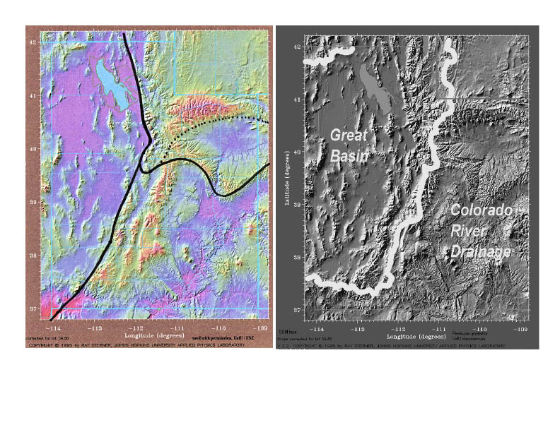
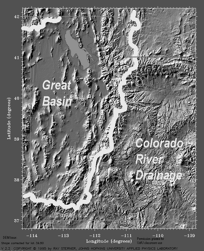
Utah’s two major drainage basins: the Colorado River Basin and the Great Basin
(the third hydrologic region is small, a tiny portion of the Snake River
drainage.
THEORY / CONCEPTS towards an understanding of
the HYDROSPHERE and geography of UTAH... reminder... geography is more than names of capitols and states... LINK
1.
Systems have subsystems. The hydrosphere is a subsystem of Earth
systems, the subsystem of water… the “water - Earth.”
Need Venn diagram of
Earth systems – subsystems
The HYDROSPHERE is
the water Earth.
The ATMOSPHERE is
the gaseous Earth that brings us weather and climate ties to the HYDROSPHERE
via the water cycle,
The BIOSPHERE is the
living Earth depend on water and create feedback loops within the water cycle,
and
The ANTHROSPHERE is
the human footprint on Earth, dependent on water and ever tinkering with its
distribution and qualities.
Reminder: systems
have subsystems that interact and have feedback loops. Embrace the complexity
of Earth systems. “It’s a loopy world” (Montague, UofU).
USGS... how to read topo maps
Thought questions:
We’ve talked about location. We’ve talked about place. What is space?
Huge geography
concept: What properties of places on Earth are continuous… meaning every
location on Earth has that property (such as temperature)? What properties is
“discrete” meaning, not continuous?
Note: if such
questions of space fascinate you… consider taking the GIS series of UofU
geography.
Every place has an
elevation (continuous data, continuous space). Every place has a temperature.
Not every place has a student, or a lake, or a rock (discrete data, object
space). Does every place have bedrock at depth?
Big concept:
continuous data of all types can be contoured.
A contour LINE is a
hypothetical line with the same value all along it. Higher values are on one
side of the line and lower values on the other.
A contour INTERVAL
is the difference in value between two contour lines.
LINK square; LINK
square with values; LINK 2 contours; LINK self quiz ; LINK to labeled contours on "quiz"; LINK to labeled
elevations on "quiz"
Here are a few LINKS
that you may find interesting about contours… how to draw and how to interpret
them:
LINK:
http://geology.isu.edu/geostac/Field_Exercise/topomaps/topo_interp.htm
USGS map series
http://mac.usgs.gov/isb/pubs/booklets/usgsmaps/usgsmaps.html
How to read USGS topographic
maps http://erg.usgs.gov/isb/pubs/booklets/symbols/
Drawing contours for
data and reading contours are skills of a geographer, skills that can help you
appreciate the geography of
OPTIONAL – how to
draw a contour map… you’ll need a set of colored pencils… and a map such as
LINK to today’s temperatures across the Nation. LINK to instructions… if you
take the time to do this exercise… you’ll be empowered!
3.
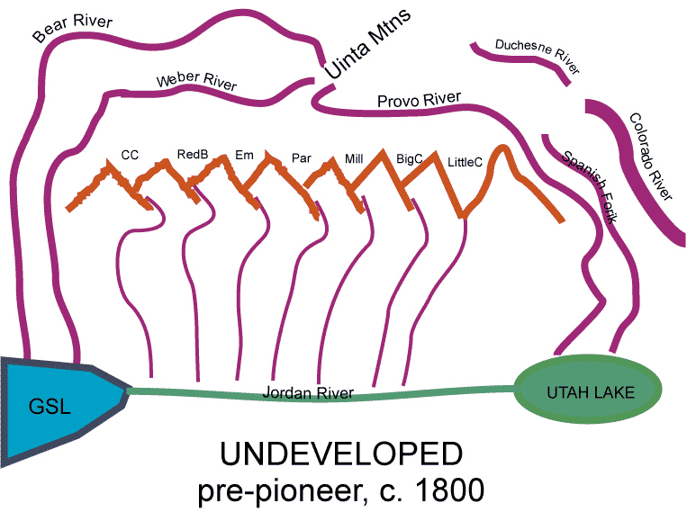
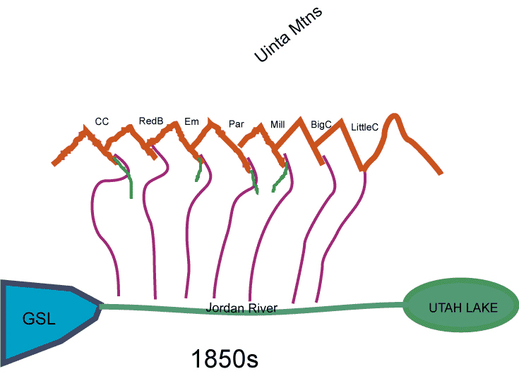
Watersheds are areas on Earth’s surface that collect water that flows to a given place. The area, however great or small that “sheds water” toward a specific place is its watershed. Divides separated watersheds. Everything goes somewhere.
Review Emigration Canyon scene EVIDENCE: OBSERVATION: (discussion below)
Google Earth, north up; Google Earth south up; Topo map note Little Mountain summit; Detail - shows drainage divide
Water flows down gradient. (Downgradient for groundwater is not always "downhill.") Where does it go?
What is “sea level”
when we talk about elevation above sea level?
Topography is the
lay of the land with respect to sea level. For the UofU… where does surface
water flow (surface water, not thinking ground water yet… not even thinking
storm drains).
Topographic maps
show topography using contours. My favorite site for contour maps are:
USGS National Map –
make map site
Google Earth app = Google "metzger willard googel earth"
Topographic maps
show which way surface water flows, the paths it takes, AND the steepness of
terrain along the way. The region that “sheds water” meaning, the region whose
area can capture surface water that then flows to or through a point, is called a
watershed.
Thought questions:
Why do historians talk about “watershed events”?
Divides separate
(divide) watersheds. Why is a ridgeline called a “divide”… what is it dividing?
Big concept: Regions
drawn on the basis of the hydrosphere are drawn based on drainages:
DIVIDE, watershed
divide, drainage divide, continental divide – (sometimes it is an obvious
ridgeline. Some places it can be subtle).
WATERSHED or
catchment
DRAINAGE – a loose
term - think of it as the stream that flows from an area ... or the surface
area that contributes water to that stream. What does "drain" mean to you?
DRAINAGE BASINS are
regions based on surface water catchment areas – remember the definition of a
region. Large areas with surface waters that drain to the same place. USGS Watersheds of US; National Atlas, (major) Watersheds of US. Basins of
NTL Atlas
4.
Rivers are fed by watersheds. Broad regions based
on watersheds are called drainage basins. Utah has two major drainage basins and a small portion of a third.
ditto
Utah
Break out your official highway map of Utah Utah DoT Highway Map
Follow water
upstream from Great Salt Lake following the big bold
Follow water upsteam
from Great Salt Lake following the Jordan River –
Follow water
upstream from the confluence of the Green River and the
Drainage means just
what it sounds like… drainage of a bath tub, to drain – Merriam Webster from
web:
: to remove (liquid) from something by letting it flow away or out
Identify the divide
between the drainages of Great Salt Lake and those of the
5.
Understand the water cycle (a.k.a. hydrologic cycle) and be empowered. The water cycle and Utah geography.
Local... adaptation of Water Cycle to SLValley
Thought questions:
Why is the hydrologic cycle so intuitive and simple versus the rock cycle?
The water cycle LINK
to USGS;
Evaporation,
condensation (next week – subsystem = the atmosphere),
Transpiration, (biosphere pumping water... then evaporated)
Precipitation (next
week - subsystem = the atmosphere),
Surface water (think
like a raindrop… this lecture) major rivers of Utah LINK
Ground water (this
lecture)
(Surface water is
two words when a noun and 1 word as an adjective, also for ground water)
Coaching: seek
empowerment through understanding… understand interactions… location, place,
movement, regions.
The water cycle and
Images:
Thought questions:
Where is the line drawn between the Atmosphere and the Hydrosphere?
Great basic source
of info. LINK to USGS pdf
PRECIPITATION: Snow, Sleet, Rain, Dew … seasonality,
quantity, spatial distribution – Atlas of
Emigration Canyon... surface waters.
Flowing water:
un-channelized flow (generally) becomes channelized flow
Unchannelized =
overland flow (general term); Sheet wash
Channelized flow =
Ephemeral flow; Intermittent stream; Perennial flow / stream; River
WATER BODIES (very
broad term, can imply slower moving… but not necessarily)
Ponds – Standing
water… even though it flows
Fresh water lakes –
Standing water… even though it flows
Closed-basin lakes –
standing water, no outlet other than via evaporation
Seas
Oceans
LOCATION and
hydrology… follow on your highway map
Major rivers:
Weber
County - scale
Natural lakes
Sevier (dry)
Reservoirs… big and
small
Colorado River system in
Flaming Gorge dam and Flaming Gorge Reservoir
Mountain Dell; Little Dell (
GROUND WATER
Unsaturated - USGS Basics … not
every hole that is connected is filled with water
Saturated … below
the water table… every hole that is connected to another hole is filled with
water.
Unsaturated zone is
important, particularly for plants… also for homes with basements... and contaminant flow.
Saturated zone
means: WHERE there are voids (open spaces “porosity”) in rock (sediment or
bedrock) and IF the open spaces are connected (“permeability”) THEN the open
spaces will be full of water.
HYDROSPHERE-GEOSPERE
interactions: not only landforms make a difference to the hydrosphere, so do
Earth materials. For example, the pore spaces of geologic materials make a big
difference to the amount of water that is stored and accessible for human use.
Aquifer: a rock body
(sediment or bedrock) that has more water than others of the region.
Artesian well: well
that taps groundwater under pressure
Flowing well: a type
of flowing well, a well that taps groundwater under sufficient pressure that
the water rises to the land surface
6.
Out of sight, out of mind. Groundwater hydrology is rarely simple... but ever more-important to human geography
Reminder... sediments and bedrock affect the amount of space available for water in rock
Permeability is the capacity for water to flow through rock... through pores, cracks, and/or caverns (NOT as underground rivers)
Great Basin hydrology case study... Salt Lake Valley
Note sediments and bedrok of basin and range:. USGS Basin Range Structure and materials
Remind yourself of what you know: Precipitation…
Surface water… Ground water… fluid flow… aquifers… confined and unconfined.
Hydrology of a type of valley found in upper reaches of the Bear, Provo, Weber, Green, and Duchesne Rivers
Rocky Mountain recharge for Colorado River drainage or Great Basin drainage
Example... Emigration Canyon (actually much more complex... this is very simplified) USGS for regional example
Hydrology of Colorado Plateau terrain of Colorado River drainage basin
USGS schematic for Colorado Plateau hydrology
For example, of Moab region... mountains such as the La Sal Mountains; discharge by springs.
Note the effect of bedrock (some are aquifers, others are "aquitards" or "aquicludes"
Note the effect of deeply incised canyons that literally "drain" the region.
And some sections of rivers "gain" water and others are losing streams... USGS schematic of gaining streams in upper reaches of Colorado River drainage basin (or upper reaches of Great Basin watershed of Uinta Mountains) and losing reaches downstream... often in urban areas.
7. Information literacy: regional hydrology might be considered "Earth sytems 101." County-scale hydrology... that's "Earth Systems 301"
What should a "geographer of Utah" be able to do with respect to hydrology?
a. Be able to classify by physiographic region and hydrologic region…
Physiographic provinces versus drainage basins:
Physiographic province (think GEOSPHERE) LINK Weber/Greer Atlas p 16
Colorado Plateau: a river runs through it
Basin and Range: rivers run to it.
Colorado River drainage basin
Great Basin
a very small portion of the Columbia River drainage basin.
b. Be able to classify by drainage system's management basin,
c. Reality check: be able to OBSERVE terrain and
scenery for characteristics of the hydrosphere.
Bowen
Hamblin-BYU
Hamblin-BYU
Hamblin-BYU
Hamblin-BYU-KingsPeak-ColoRiverDrainage Basin
Identify patterns,
watersheds and divides… generalities… from highway map.
Look for evidence of
snow, runoff, standing water, erosion / deposition, evaporation, human
footprint (agriculture, dams/reservoirs, diversions).
Does the surface
water of the scene looks like it runs
To the scene
Through the scene
From the scene
Identify features of
surface water: (standing water; rivers; drainage patterns, evidence of flowing
water; vegetation):
d. Infer… ground water (easy to mis-interpret…
optional… embrace uncertainty). The intimate connectedness of conditions of the
geosphere and hydrosphere mean definitional complexity. Earth scientists who
understand hydrology have good jobs and interesting lives.
I
Bowen
Hamblin-BYU
Hamblin-BYU
Hamblin-BYU
Hamblin-BYU-KingsPeak-ColoRiverDrainage Basin
HUMAN GEOGRAPHY... (above sections have been dominantly physical geography... the following are human geography implications for Utah.)
8. Utah is a water-scarce state with highly uneven distribution of the resource. Of course water is managed intensely.
Abundant information
exists on
Anderson 2002, The
Colorado River,
Utah - Water plans by basin -- Terrific for county level info.
Land use, water use
by basin, for example,
LINK to analysis --
Isaacson UBEBR LINK
Discussion of water
politics "conservative" (broken) LINK to Utah Foundation
Overview of issues
from the Utah Water Plan
Per capita consumption
UtPlan09
Population projections
UtPlan07
Demand projections for
Municipal and Industrial UtPlan10
Uses of water
UtPlan11;
Uses of water by basin
UtPlan12
9. Wet water versus paper water… water resources versus water rights. Water rights govern water usage.
Uneven distribution of
water
Understand: water
rights, water exchanges
Concept of WATER
RIGHTS.
LINK to Wikipedia on
the subject: Water Rights
Riparian... it's
there, along a stream, stream bank owner has a right NOT
Water right, is the
right to use the water. The State of
Restated:
Petition for a water
right: based on point of diversion, based on beneficial use, based on your
ability to put it to use
Prior appropriation
(first in time, first in right) means your right to use water is subservient to
those who already have rights.
Water rights may be
exchanged: exchange the right to use water (location, time, purpose)… for a
right to use different water (location, time, purpose).
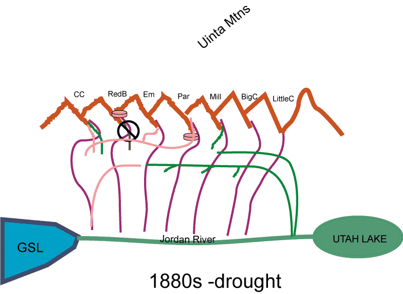
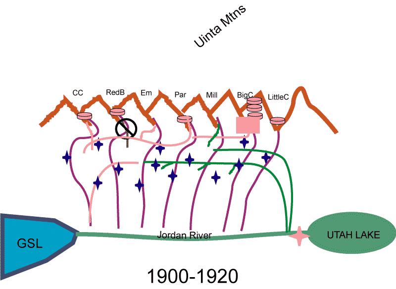
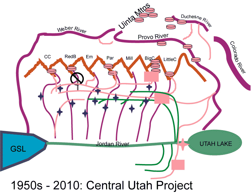
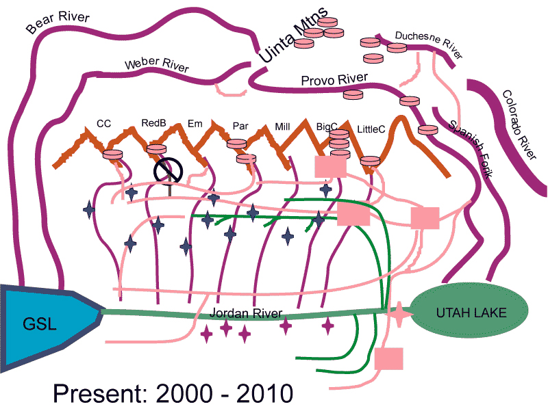
10. Urban water supplies may come from afar… dams, diversions, politics, and water. First in time, first in right. Case history of water appropriations: sources of UofU drinking
water. A history of
Case history –
When I say “give me the chorus…” I want you to say… mentally or out-loud “MORE WATER!!”
History of
the development of
|
|
|
|
|
|
|
|
|
|
|
|
|
|
|
|
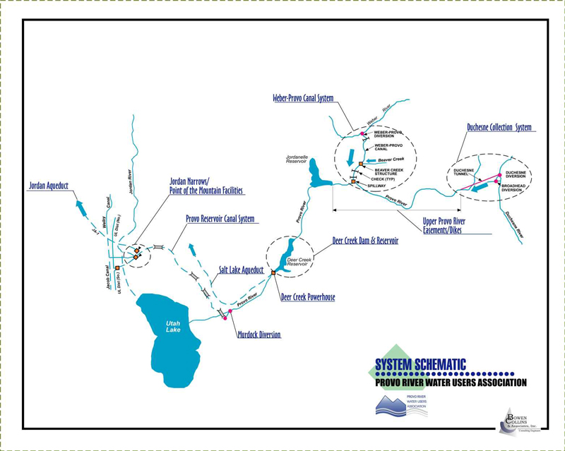
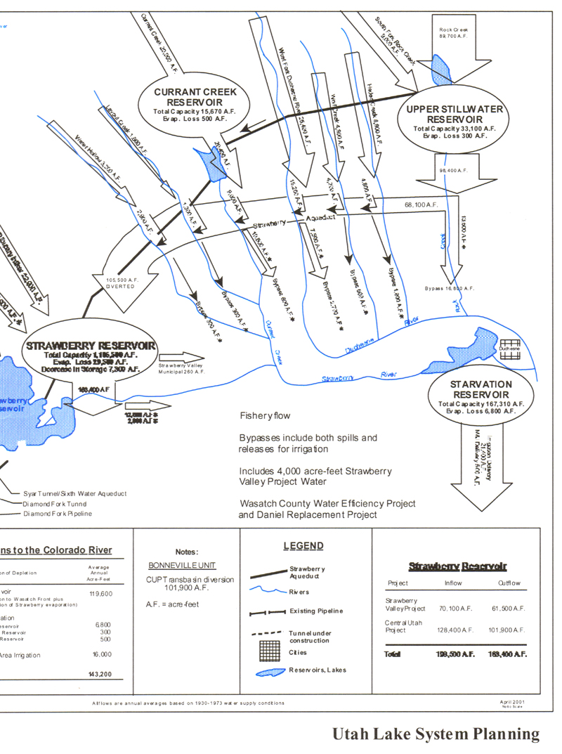
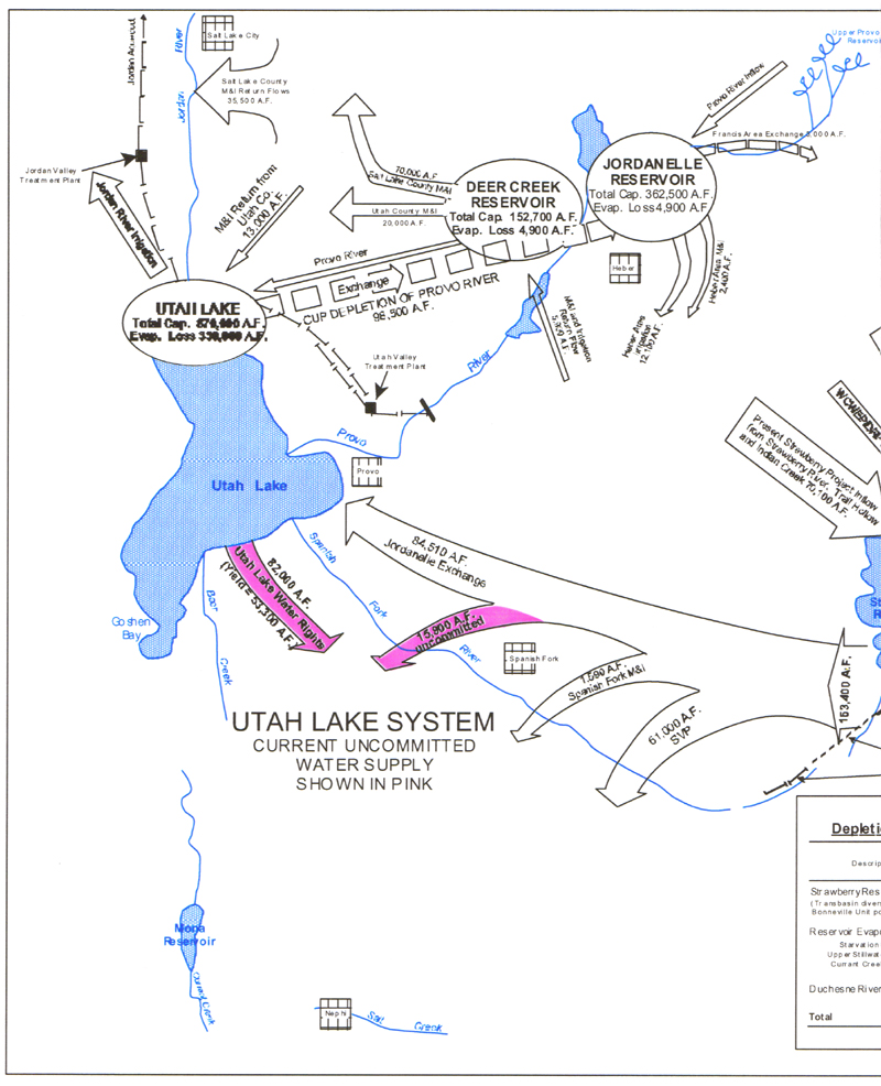
PRWUA system (the board I serve on)... Provo River Water Users Association Central Utah Water Conservancy -
|
|


FOR TIM'S class y130530 -- CASE HISTORY
Provo River Water Users part of SLC and others' water LINK
GRAPH to sort of understand 02
13
FINAL SECTION OF THIS CHAPTER… IMPORTANCE of Utah's HYDROSPHERE to others of the 15 themes of Geography of Utah.
How the HYDROSPHERE
matters to the physical and human geographies of
Know where you are,
know who you are.
And be empowered to
lead a good life… that’s the underlying assumption of UofU Geography
of
Let me count the
ways!! By using the 15 x 15 matrix.
For the five
subsystems of Earth systems….
Feedback loops and
interactions are so numerous it can be difficult to articulate where
hydrosphere ends, for example, and atmosphere (weather and climate) begin. Good
luck.
For the 5 themes of
geography… these are pretty straightforward… location… place… interaction…
movement/migration… and regions. Water flow is all about movement/migration.
Location of
For the 5 issues of
social and behavioral sciences (economics; demographics; political science;
sociology; and quality of life): this chapter provides some insights on
political science, sociology, and quality of live with respect to the
hydrosphere. Economics may not have been covered directly, here are a couple
LINKS.
SELF QUIZ
By the end of this
chapter… you should:
Understand what the
HYDROSPHERE includes, and that it is one of the five subsystems of Earth
systems (physical geography).
• Understand why
the boundaries of
• Be able to adapt concepts of the
water cycle to
• Be able to name and approximately
locate about 20 features of
• Given images of
• Water management: know where to find
information about the management of
• Water politics - that “liquor is for
drinking and water is for fighting”
• How and why surface waters are
diverted... water right
• Be able to give a very general
description of where water that is in the sinks and water fountains of Marriott
Library, UofU might come from… on a hot summer day.
SUMMARY:
Regions of
Basin and Range
(rivers run to it)
Colorado Plateau
(rivers run through it)
Drainage basins –
based on watersheds of the hydrosphere – water quantity, seasonality, water
rights
And a very small
part of the Snake River /
Tectonics rules! ... but don't forget water and Utah politics.
These regions are
defined based on watersheds, using terrain, and, specifically using contoured
elevation data.
The case history of