HISTORY of the growth of
For
MAY 12, 2011 –
THE GOAL – imagine you are a raindrop destined to
reach Salt Lake Arts Academy… perhaps for a drink of water for a thirsty student…
or the flush of the toilet…
Where might you start your journey?? What are the
legal ways you arrive as well as the physical ways??
THE PLAN
PART 1 – ORIENTATION –
A few concepts
A few maps
PART 2 – LECTURE… history using words and screen
images… PLUS a chorus of “more water”
PART 3 – Go outside
(a) Directional yoga: stretch in the general direction
of where major sources of
(b) RE-ENACT the history, outside.
Meaning… each student represents water that will end
up in
PART 1 - ORIENTATION
A couple concepts and a couple maps.
BIG CONCEPT #1…
“
True… but some of the state gets a lot of water
Darkest blue is more than 50 inches / year:
Pale yellow is less than 6 inches / year
Where is
So… where are likely places for SLC water supplies to come from?
ORGANIZE CHORUS… “More Water!”
You’ve seen what areas of
CHORUS….
Where where are some streams with lots of water?
Hmmmm This will take some engineering!! CHORUS
BIG CONCEPT #2 -- WET WATER versus PAPER WATER…
Just because you live along a stream in
Utah’s water belongs to the state; you can petition to
have a right to use it... and if you get that right... you get to use that
water… after others (who filed ahead of you) have used their rights (first in
time, first in right).
Water rights are based on
·
Point of diversion (there has to be water there),
·
Based on beneficial use (there has to be a human-based
need),
·
Based on an ability to put it to use (there has to be
a plan to develop it).
For our example…
·
IF water is there to be filed on
·
IF SLC can show it needed the water (CHORUS) and
·
IF SLC can show it can get the water to SLC
·
PART 2 – LECTURE… history using words and screen
images… CHORUS
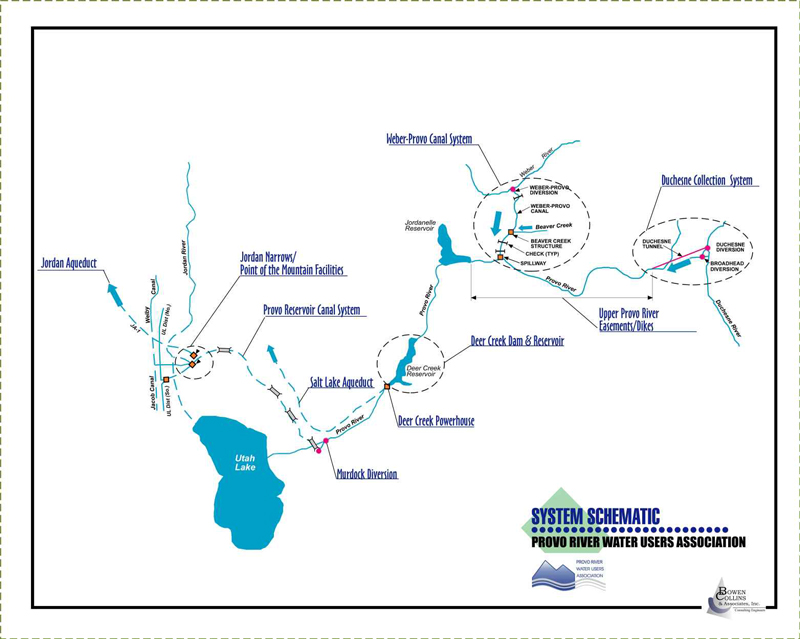
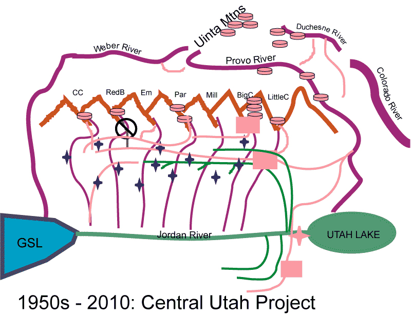
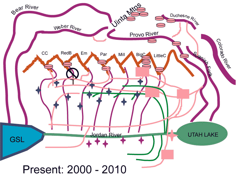
SCHEMATIC of
Another schematic showing the sources looking EAST
across the
Opening image...
Another view showing DUCHESNE diversion team's path to SLARTS.
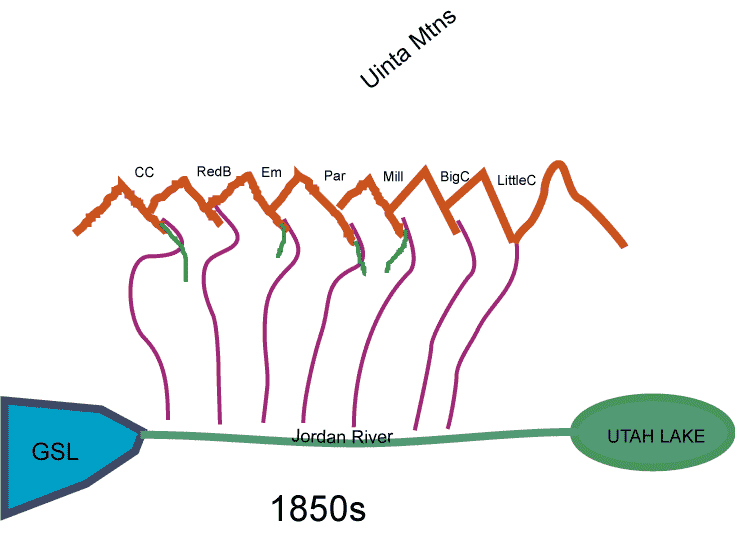
HISTORY OF WATER DEVELOPMENT –
You’ve arrived in Salt
Water and safety determine where you settle.
Where would you establish the town of

SETTLERS
Where did the LDS settle?
What did they need water for?
What water would you develop?
What would be great about this water... and not so good?
Why "more water"??
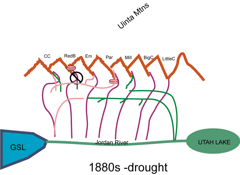
DROUGHT...

CHORUS
DROUGHT
MORE PEOPLE
GROUND WATER
SURFACE WATER in WASATCH FRONT CANYONS
CHORUS
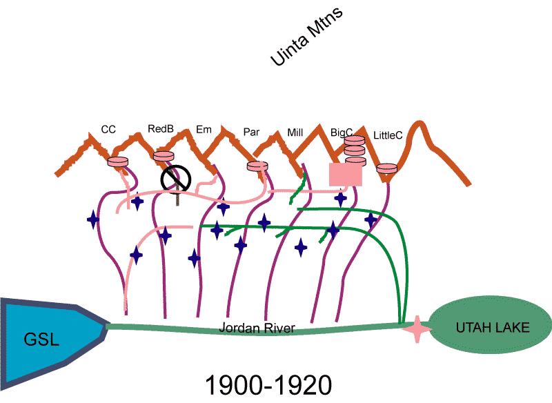
DROUGHT
MORE PEOPLE
WHERE'S THE WATER??
UINTA MOUNTAIN SOURCES
Weber River, Provo River... and why stop there?

CHORUS
DROUGHT
MORE PEOPLE
WHERE'S THE WATER...
UINTA MOUNTAINS... why not get Colorado River drainage waters?
CHORUS
DROUGHT
MORE PEOPLE
WHERE'S THE WATER... Colorador River system...
Headwaters... diversions... reservoirs...
WHY NOT THE BEAR RIVER??
Or the GREEN RIVER north of the Uinta Mountains....
FINAL CHORUS!!
Here’s terrific web site: http://www.slcgov.com/utilities/ud_source_protection.htm
TODAY’S PRESENTATION is at: http://www.earthscienceeducation.org
PART 3 – Go outside
(a) DIRECTIONSL YOGA: point in the general direction
of where major sources of
(b) RE-ENACT the history. Make like raindrops on their
journey to
Meaning… each student represents water that will end
up in